6 Days on the Pacific Coast Highway: The Ultimate California Road Trip Itinerary
- Logan & Audri

- Sep 23, 2025
- 22 min read
Updated: Jan 26
There’s a reason people call the Pacific Coast Highway one of the most beautiful scenic drives on earth, and we’d even argue it gives Italy’s Amalfi Coast a run for its money. Stretching just over 650 miles, the Pacific Coast Highway winds along California’s coast from north to south. While every mile has something to offer, the most spectacular stretch is between San Francisco and Los Angeles, and that’s exactly what this 6-day itinerary will focus on.
Over the course of almost a week, this drive takes you from San Francisco’s Golden Gate Bridge down to the beaches of Los Angeles, with unforgettable stops in between: Point Lobos, Big Sur, Santa Barbara, and Malibu, plus a few lesser-known gems along the way.
This guide shares the exact Pacific Coast Highway itinerary we recommend, packed with must-see stops, hidden gems, and insider tips to make the most of every mile. If you’ve ever dreamed of the ultimate California road trip, this is the one!

Table of Contents
When to Drive the Pacific Coast Highway
We drove the Pacific Coast Highway in February, and while the views were incredible, it was definitely on the chilly and windy side.The best part about going in the off-season was having the road nearly all to ourselves, no tour buses, no traffic, and no crowded viewpoints. If you want peace and quiet, winter can be magical.
That said, most people find the best time to drive the PCH is between late spring and early fall (April–October) when the weather is warmer and the days are longer. Summer is the most popular season, which means more crowds and higher hotel prices, but also lively beach towns and plenty of sunshine.
If you want the best of both worlds, try the shoulder months, April, May, September, or October, when the weather is mild and the crowds are thinner. No matter when you go, the Pacific Coast Highway is unforgettable, just pack for layers, because the coast has a mind of its own when it comes to fog and wind.

6-Day Pacific Coast Highway Itinerary at a Glance
Here’s a quick look at how to spend 6 days driving California’s most iconic stretch of the Pacific Coast Highway, from San Francisco to Los Angeles. You’ll find the detailed day-by-day breakdown just below this overview.
Day 1: San Francisco → Monterey
Day 2: Monterey→ Big Sur
Day 3: Big Sur → San Simeon → Morro Bay
Day 4: Morro Bay → Santa Barbara
Day 5: Santa Barbara → Malibu → Santa Monica
Day 6: Los Angeles
Pacific Coast Highway Interactive Map
To help you follow along, we created a Google My Map with all the stops from this itinerary. You can zoom in, save it to your own Google Maps, and even use it for navigation during your trip.
Day 1: San Francisco to Monterey
Your Pacific Coast Highway road trip kicks off in San Francisco, a city that deserves at least a full day on its own. But if you’re short on time, this first day balances popular landmarks with coastal stops as you make your way south to Monterey. The drive is about 120 miles, but with so many viewpoints and charming towns along the way, you’ll easily fill the day with stops along the way.
Stop 1: Golden Gate Bridge
There’s no better way to start this adventure than crossing the Golden Gate Bridge. The bridge itself is only 1.7 miles long, but the viewpoints on both sides are what make it unforgettable.
On the north side, Battery Spencer gives you the signature view of the bridge with the city behind it. On the southern side, Crissy Field offers an easy walk along the waterfront where you can frame the bridge with beaches and sailboats. If you don’t mind a short but steep trail, Marshall’s Beach gives one of the most dramatic angles of the bridge.
Even if you’re eager to keep driving, plan on 30–45 minutes here, the views are too good to rush, try to stop at one or two of these viewpoints. They’re close together, and each one shows a completely different side of this iconic landmark.

Stop 2: Pier 39 & the Sea Lions
After crossing the Golden Gate, head down to Pier 39 on Fisherman’s Wharf before officially leaving San Francisco. Yes, it’s touristy, but it’s also home to one of the most entertaining sights on the waterfront, the sea lions. Dozens of them lounge across floating docks just off the pier; it’s noisy, a little smelly, but definitely something you'll remember forever.
Pier 39 itself is full of shops and restaurants, but you don’t need to spend much time here. Grab a sourdough bread bowl from Boudin Bakery (a San Francisco classic) before spending a few minutes watching the sea lions bicker and flop around. It’s an easy stop, it’s fun, and it’s the perfect way to end your time in San Francisco before following Highway 1 south.

Stop 3: Half Moon Bay
Leaving the city behind, your first real taste of the Pacific Coast Highway comes at Half Moon Bay. This small coastal town is known for its long sandy beaches and high coastal cliffs, making it a nice stop before the scenery starts getting better and better…
If you’re short on time, Half Moon Bay State Beach is the easiest place to stop. It’s right off the highway, offers plenty of space to stretch your legs, and gives you classic views of the Pacific. If you’d rather take in the cliffs, walk the public trail near the Ritz-Carlton Half Moon Bay. The path follows the edge of the bluffs and delivers wide, unobstructed views of the ocean, one of the prettiest vantage points in this part of the drive.
This stretch of coastline is also a popular surf spot, so don’t be surprised if you see surfers out in the water. Whether it’s a quick walk, a photo stop, or just a chance to breathe in the ocean air, Half Moon Bay is an easy and worthwhile stop before continuing south.

Stop 4: Martin’s Beach
Just a few miles south of Half Moon Bay, you’ll find Martin’s Beach, a quiet beach that many people drive right past without realizing it’s there. The beach itself is stunning, a wide crescent of sand framed by cliffs, with a dramatic sea stack rising out of the water. It’s not as busy as the state beaches nearby (we were the only ones there), which makes it a nice stop if you want a quieter stretch of coastline.
Getting here is a little different than other stops. The beach sits within a small neighborhood, and if you want to park close to the sand, it’s $10 cash per vehicle. If you’d rather skip the fee, there’s a pull-off just before the turn into the neighborhood where you can park for free and walk in. Either way, make sure to be respectful of the homeowners and the properties along the beach, this is a residential area as much as it is a coastal stop.

Stop 5: Santa Cruz
Santa Cruz is California’s original surf city, and that’s what sets it apart from other coastal stops on this drive. The waves here have been drawing surfers for generations, and the town still revolves around that laid-back, surf-first culture. The best place to see it in action is at Steamer Lane, one of the most famous surf breaks in the state. There’s even a small Surfing Museum inside a lighthouse on the bluff, giving a quick look at the city’s surf history.
If you have extra time, you can swing by the Santa Cruz Beach Boardwalk for a dose of nostalgia with old-school rides and carnival games. The Santa Cruz Wharf is busy and touristy, but it’s also an easy place to grab food and look for sea lions below the pier.
From here, it’s about a 45-minute drive south to Monterey, where you’ll wrap up your first day on the Pacific Coast Highway.

Stop 6: Overnight in Monterey
End your first day of the Pacific Coast Highway in Monterey, a coastal city that makes a convenient overnight base before heading into Big Sur. Monterey has plenty of hotels and restaurants, so it’s convenient if you just want an easy place to rest after a full day of driving.
If you arrive with extra time, take a quick stroll along Cannery Row, the city’s historic waterfront district lined with shops and restaurants. The Monterey Bay Aquarium is also here and is one of the best aquariums in the world, though you’ll want to plan a couple of hours if you decide to visit. Otherwise, this is a good night to relax, grab dinner by the water, and get ready for the more rugged coastline you’ll be driving tomorrow.

Day 2: Monterey to Big Sur
Day 2 is where the trip really starts to feel like the Pacific Coast Highway you’ve been picturing. You’ll leave Monterey behind and make your way through Carmel, Point Lobos, and into Big Sur, you’ll pass storybook towns, protected coves, and some of the most photographed stretches of coastline in California. Even though the mileage isn’t huge, it’s a full day of stops and scenery before you spend the night in Big Sur.
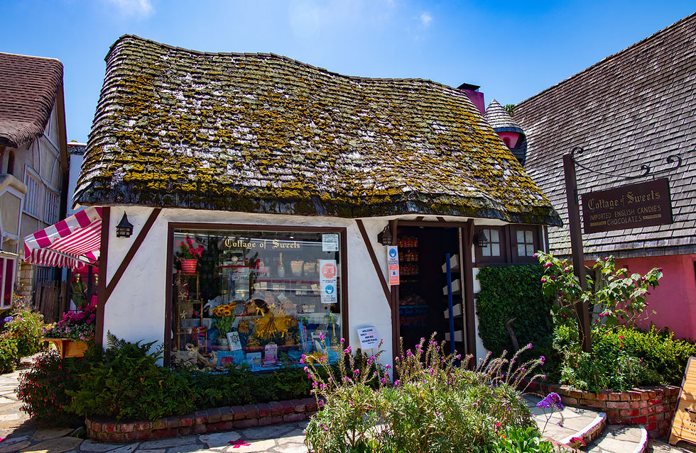
Stop 1: Carmel-by-the-Sea
Your first stop is Carmel-by-the-Sea, only a short drive from Monterey, but it feels like a completely different world. The town is known for its fairy-tale cottages, narrow streets, and dozens of art galleries, all packed into a walkable downtown. It’s small, but it’s a place that’s best enjoyed on foot, even if you only have an hour.
One of the best reasons to stop here is the beach. Carmel Beach is a wide stretch of soft sand with views that stretch all the way down the coast. It’s especially beautiful in the morning when the light is soft and the crowds haven’t arrived yet.
If you have time for a scenic drive, the entrance to the 17-Mile Drive is right here. It’s a paid scenic route that winds past famous golf courses, rocky coastlines, and luxury homes, eventually looping back toward Monterey. It adds extra time to your day, but if you’re looking for dramatic coastal views and don’t mind the detour, it’s worth considering.
Stop 2: Point Lobos State Natural Reserve
Just a few minutes south of Carmel, you’ll reach Point Lobos State Natural Reserve, often called the “crown jewel” of California’s state parks. It’s a compact, but stunning area where cliffs, turquoise coves, and cypress groves make this one of the most memorable sections of the coast.
The park is best explored on short, easy trails that give you a lot of reward without much effort. The Cypress Grove Trail is a must, it loops through Monterey cypress trees with beautiful views of the ocean below. Another one of our favorites is the Sea Lion Point Trail, where you can usually hear sea lions barking long before you see them on the rocks offshore. Wildlife spotting is a big part of the experience here: keep an eye out for sea otters floating in the kelp beds and, in the right season, whales spouting just offshore.
Parking inside the reserve can be very limited, especially later in the day, so arriving in the morning is your best bet. If the lot is full, you can usually find a spot along Highway 1 and walk in. However the walk can be pretty far depending on how busy it is and which trails you want to go to. Point Lobos was our absolute favorite stop on the Pacific Coast Highway, so definitely not miss it!

Stop 3: Bixby Bridge
As you continue south into Big Sur, the road snakes along the edge of the coastline until you reach Bixby Creek Bridge, a spot you’ve probably seen in countless photos, but it’s even better in person. Built in 1932, the bridge is 280 feet above the canyon below, with the Pacific stretching out endlessly behind it. Even if you’ve seen it in a dozen photos, pulling over and seeing it in person is a completely different experience.
The most popular viewpoint is just before you cross the bridge heading south. There’s a pull-off on the right where you can park, walk a short distance, and capture that classic angle of the bridge curving into the cliffs with the ocean in the background. There are a few smaller pull-offs on the north side as well, but parking here can be tight and fills up quickly, especially midday.

Stop 4: Pfeiffer Beach
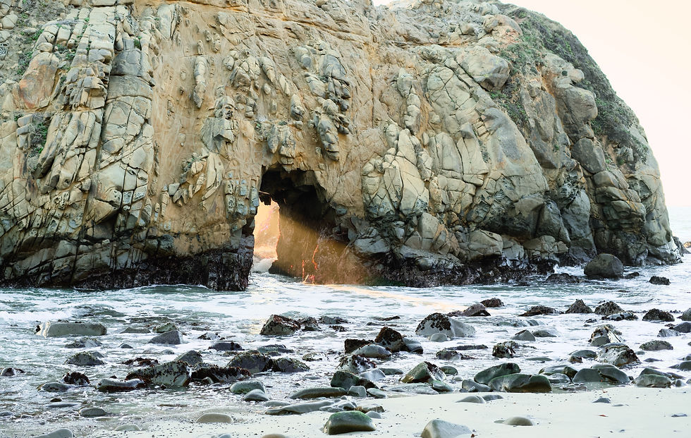
Tucked just off Highway 1, Pfeiffer Beach stands out for two reasons: its purple sand and the massive sea stacks that rise from the water. The most well-known sea stack is Keyhole Rock, a natural arch where the waves crash through the opening. At sunset, the light often streams directly through the arch, making it one of the most breathtaking spots in Big Sur.
Finding the beach can be a little tricky. The turnoff is marked only by a small yellow sign that says “Narrow Road” about a mile from Pfeiffer Big Sur State Park. From there, it’s a two-mile drive down a narrow, winding road that leads to the parking lot. There’s a fee to park, $15 per vehicle, and the lot is small, so it’s smart to arrive early in the day or closer to evening.
Pfeiffer Beach isn’t great for swimming because of the strong waves, but wandering the shoreline and watching waves crash through the Keyhole Rock arch is the highlight.
Stop 5: McWay Falls
Just south of Pfeiffer Beach, you’ll find McWay Falls, one of the most famous viewpoints in Big Sur. Here, an 80-foot waterfall drops from the cliffs into a hidden cove, creating a view that shows up on just about every postcard of Big Sur, and for good reason.
Visiting is simple, but first-timers don’t always know that you actually park across the street in the Julia Pfeiffer Burns State Park lot. From there, a staircase takes you down to a tunnel that runs beneath Highway 1. On the other side, a short, flat trail leads directly to the overlook. The walk is short, but the view is one of the best highlights of the entire drive.
You can’t hike down to the beach itself, so the view from above is the way to experience McWay Falls. If you have flexibility in your timing, aim for later in the afternoon when the cove lights up and the water glows turquoise.

Stop 6: Overnight in Big Sur
After a full day of exploring Carmel, Point Lobos, Bixby Bridge, Pfeiffer Beach, and McWay Falls, spend the night in Big Sur Village. Staying here means you can enjoy this stretch of the Pacific Coast Highway once most visitors have gone, and wake up surrounded by redwoods and ocean views the next morning.
Big Sur doesn’t have a traditional town center, but there are a handful of lodges, cabins, and campgrounds along Highway 1. Choices range from simple campsites to comfortable spots like Big Sur Lodge or Glen Oaks Big Sur, both conveniently located near hiking trails and viewpoints. Accommodations are limited and book up quickly, so it’s best to reserve well in advance.
Ending the day in Big Sur keeps the driving time reasonable and keeps you right in the heart of Big Sur, surrounded by redwoods and ocean cliffs, making it the perfect base before continuing south toward San Simeon and the Central Coast on Day 3.

Day 3: Big Sur to Morro Bay
Day 3 is all about variety. You’ll finish Big Sur’s coastline, step into redwood groves at Limekiln, see hundreds of elephant seals on the beach near San Simeon, and tour Hearst Castle before ending the day with spectacular views in Morro Bay.
Stop 1: Limekiln State Park
Near the southern edge of Big Sur, Limekiln State Park packs a lot into a small area. There’s short trails that take you through redwoods, past creeks, and up to the remains of historic lime kilns that once operated here in the late 1800s.
One of the highlights is the Limekiln Falls Trail, an easy hike of less than a mile that leads to a 100-foot waterfall tucked into the forest. There’s also a short trail to the beach, where you’ll find a beautiful secluded cove. Because the park is compact, you can see the highlights in under an hour and still keep your day moving. Parking is limited and requires a $10 fee, so it’s best to arrive earlier in the day.

Stop 2: Elephant Seal Vista Point
Just north of San Simeon, pull over at Elephant Seal Vista Point, where thousands of elephant seals gather on the beach throughout the year. It’s one of those stops that catches almost every traveler by surprise because you don’t expect to see animals this massive sprawled out across the sand right next to Highway 1.
A wooden boardwalk runs along the bluff, giving you safe and clear views of the colony below. What you’ll see depends on the season. From late January to early March, it’s pupping season, and the beach is filled with mothers and newborn pups. In fall, juveniles crowd the sand and practice their loud, clumsy sparring. Even in the quieter months, there are almost always seals here, some weighing over 5,000 pounds!
The stop is completely free, parking is right next to the overlook, and you can easily spend 20–30 minutes watching the action. If you’re traveling in peak season (winter or early spring), plan a little extra time, the chaos and personality of hundreds of seals competing for space is unforgettable.

Stop 3: Hearst Castle
In San Simeon, Hearst Castle dominates the hillside above the ocean, visible long before you reach the visitor center. Built by William Randolph Hearst in the early 1900s, the estate combines European-inspired architecture with extravagant gardens and two famous pools, the Neptune Pool and the indoor Roman Pool.
Visits are by guided tour only, and there are several options depending on your interests. The Grand Rooms Tour is the most popular for first-time visitors and covers the main entertaining spaces inside the mansion. Other tours highlight the upstairs suites, the kitchens, or the gardens. Tickets can sell out in peak season, so booking ahead online is recommended.
You’ll park at the visitor center just off Highway 1 and take a shuttle bus up the hill to the estate itself. Plan on spending two to three hours here, including the tour and some time to explore the grounds. Even if historic sites aren’t usually your thing, the sheer scale and detail here are hard to ignore.

Stop 4: Moonstone Beach Boardwalk (Cambria)
South of San Simeon, the Moonstone Beach Boardwalk is an easy place to walk right along the water. The boardwalk runs for about a mile along the shoreline, offering easy access to tidepools, driftwood-covered sand, and wide views of the Pacific. It’s flat and simple to walk, so you can spend as little or as much time here as you want.
The beach gets its name from the smooth “moonstones” and other colorful pebbles that sometimes wash up on shore, making it fun to explore if you like hunting for details in the sand. At low tide, tidepools appear along the rocks, often filled with sea stars, crabs, and anemones.
Parking is free and available in lots along Moonstone Beach Drive, with multiple access points to the boardwalk. If you need a break, grab a bench overlooking the water, on the right day, you might spot dolphins or even whales offshore.

Stop 5: Overnight in Morro Bay
Your last stop of the day is Morro Bay, a small seaside town defined by its landmark, Morro Rock. This volcanic plug rises 581 feet above the shoreline and can be seen from miles away as you approach. A road leads right out to the base, making it easy to get a close look before heading into town.
The beach next to the rock is wide and open, sunset here is especially amazing, with the ocean on one side and Morro Rock towering on the other. In the harbor, keep an eye out for sea otters floating on their backs, often with pups in tow. It’s one of the best places along the Central Coast to reliably spot them.
Downtown Morro Bay, especially along the Embarcadero, has plenty of restaurants, small shops, and hotels overlooking the water. kayaking and paddleboarding are popular too. Most travelers spend the night here since it’s a relaxed, convenient spot to stay before the drive to Santa Barbara.

Day 4: Morro Bay to Santa Barbara
Day 4 takes you from Morro Bay to Santa Barbara, with plenty of variety packed into a shorter driving day. You’ll detour to Montaña de Oro for coastal views, stop in Pismo Beach, wander the Danish-style streets of Solvang, and wrap up the day by the water in Santa Barbara.
Stop 1: Montaña de Oro State Park
South of Morro Bay, Montaña de Oro State Park offers a quieter piece of coastline, with hiking trails, tidepools, and a sheltered cove tucked right next to the parking lot. The park’s name means “Mountain of Gold,” a nod to the yellow wildflowers that fill the hills in spring, but it’s worth visiting year-round.
The highlight here is the Bluff Trail, a walk along the edge of the coastline with nonstop views of sea caves, tidepools, and the waves below. If you have more time, the Valencia Peak Trail is a steeper hike that rewards you with panoramic views of the ocean and surrounding hills. For something quick, you can simply drive to Spooner’s Cove, a sheltered beach right next to the parking lot that’s perfect for a short stop.
Because it’s a little off the main highway, Montaña de Oro doesn’t draw the same crowds as the bigger state parks along the highway, so it’s a nice change of pace. It’s a great way to start the day before heading back to Highway 1 and continuing south toward Pismo Beach.
Stop 2: Pismo Beach
About half an hour south of Morro Bay, you’ll find Pismo Beach, a classic beach town with enough to keep you busy for an hour or two. Most people head straight for the Pismo Pier, where you can walk out over the water and watch surfers working the waves on either side.
If you want something different, drive a few minutes south to the Oceano Dunes. It’s one of the only places in California where vehicles are allowed on the beach, so you’ll usually see trucks and ATVs out on the sand. Even if you don’t drive on the sand, the sight of the dunes meeting the ocean is impressive.
Depending on the season, you might also catch a natural highlight, from late October through February, thousands of monarch butterflies gather in the Monarch Butterfly Grove just south of town. It’s free to visit and worth a quick stop if you have time to spare.

Stop 3: Solvang
Leaving the coast for a short detour inland, you’ll reach Solvang, a Danish-inspired village tucked into the Santa Ynez Valley. The town was founded by Danish immigrants in the early 1900s, and today it’s known for its windmills, half-timbered buildings, and bakeries serving traditional pastries like aebleskivers and kringle.
The main streets are easy to explore on foot, with plenty of shops, wine-tasting rooms, and cafés. Even if you’re just passing through, it’s worth a quick stroll to see the European architecture and grab a pastry before getting back on the road. If you have more time, the Santa Ynez Valley around Solvang is packed with wineries and tasting rooms.
Because it’s directly off Highway 101, Solvang doesn’t add much time to your drive, making it an easy stop on the way to Santa Barbara.

Stop 4: Overnight in Santa Barbara
End the day in Santa Barbara, often nicknamed the “American Riviera” for its Spanish-style architecture, palm-lined beaches, and mountain backdrop. It’s bigger than the coastal towns you’ve passed so far, but it still feels relaxed and easy to explore.
If you arrive with time, start with a walk along Stearns Wharf, where you can grab an ice cream and watch the sunset over the water. A few blocks inland, State Street runs through the center of downtown with shops, restaurants, and outdoor cafés. For a quieter break, the Santa Barbara Mission offers a look at the area’s history.
Santa Barbara has a wide range of places to stay, from boutique inns to larger hotels right on the beach. It’s the perfect spot to rest up, because tomorrow the drive continues south toward Malibu and the final stretch into Los Angeles.

Day 5: Santa Barbara to Santa Monica
Once you leave Santa Barbara, Highway 1 takes you into Southern California’s beach culture, long stretches of sand, surfers out in the water, and oceanfront houses stacked right against the road. Malibu is the highlight, with beaches that range from wide and sandy to hidden coves tucked below cliffs. By the end of the day, you’ll roll into Santa Monica, where the pier and busy boardwalk kick off the Los Angeles part of the trip!
Stop 1: Carpinteria State Beach
Fifteen minutes south of Santa Barbara, Carpinteria State Beach is the kind of place locals go when they don’t feel like driving all the way to Malibu. It’s wide, sandy, and easy to access, which makes it a simple but worthwhile stop.
If you’re here at low tide, walk down to the tidepools at the southern end of the beach, starfish, crabs, and sea anemones are common. Just above the water, the Carpinteria Bluffs Trail runs along the cliffs with a good chance of spotting sea lions on the rocks below. Parking is straightforward, right next to the sand, so you can be in and out quickly if you’re short on time.

Stop 2: El Matador Beach (Malibu)
By the time you hit Malibu, the beaches look like they belong in a movie, and El Matador Beach is the one you’ll probably recognize from Instagram. From the parking lot, a staircase leads down to a stretch of sand framed by caves and huge sea stacks.

At low tide, you can walk between the caves and explore the rock formations up close. At high tide, the beach narrows, but the views from the cliffs above are still worth the stop. Photographers love it at sunset, when the rocks cast long shadows across the water.
Parking is limited and fills quickly, so aim for early morning or later in the afternoon if you want the beach to yourself. It takes a little effort to reach compared to other Malibu beaches, but the setting makes it one of the most memorable stops of the day.
Stop 3: Malibu Pier & Surfrider Beach
Just down the road, Malibu Pier and Surfrider Beach give you the classic SoCal surf scene. The pier itself dates back to the 1930s and is lined with shops and cafés, but the real action is in the water, surfers carving waves at one of the most famous surf breaks in California.
Walk the pier for views back toward the Santa Monica Mountains, or grab a coffee and watch the sets roll in. If you’re into history, the nearby Adamson House and Malibu Lagoon Museum tell the story of Malibu’s ranching and surf culture, but even a quick stop delivers the vibe: surfers, lifeguard towers, and oceanfront homes that define Malibu.
Parking can be tricky near the pier, so budget a little extra time for finding a spot. This stop isn’t about rushing, it’s about taking in what Malibu is all about.

Stop 4: Overnight in Santa Monica
Finish the day at the Santa Monica Pier, where the Pacific Coast Highway meets Los Angeles. The pier is packed with an amusement park, arcade, and food stalls, but it’s the setting that makes it so popular. Standing at the end, you’ll have views of the wide beach stretching north toward Malibu and south toward Venice.
Sunset is the best time to be here, the Ferris wheel lights up as the sky turns orange and pink. It’s busy and touristy, but it’s also the perfect bookend for your Pacific Coast Highway trip.
Santa Monica is an ideal overnight stop, there’s plenty of hotels, restaurants, and easy access to both the beach and the rest of Los Angeles. It’s a lively place to wrap up your coastal drive before your final day in the city.

Day 6: Los Angeles
Your last day on the Pacific Coast Highway lands you in Los Angeles, where the road trip officially wraps up. Unlike the quiet stretches of Big Sur or the small towns on the Central Coast, LA is big, busy, and packed with options. How you spend the day depends on your style, stick to the beach, head into the hills, or dive into the city.
Stop 1: Griffith Observatory
Griffith Observatory is the best place to get your bearings in Los Angeles. From the terraces, you can see the downtown skyline in one direction, the Hollywood Sign in another, and on a clear day the ocean stretching out in the distance. It’s free to visit, and while the exhibits inside are interesting, most people come here for the views.
Parking can be a little tricky. If you’re lucky, you’ll find a spot in the lot right at the top, but more often you’ll need to park along the road lower down and walk up. Shuttles run from the Greek Theatre lot if you’d rather save the climb.
Even if you’ve seen a hundred photos of the Hollywood Sign, standing here makes it feel real. The scale of the city, the sprawl of neighborhoods, and the mountains in the distance all come together in one place. It’s a view that makes you realize just how far the Pacific Coast Highway has taken you.

Stop 2: Beverly Hills
Beverly Hills is the LA you’ve seen in movies a thousand times, and walking through it feels a little surreal. Rodeo Drive is the centerpiece, with luxury shops and polished storefronts that make it one of the most famous shopping streets in the world. Even if you’re not buying anything, strolling a few blocks here gives you the sense of why it’s such a landmark.
Just beyond the shops, the neighborhood changes into quiet, palm-lined streets lined with mansions. You don’t need a map, simply wandering a few blocks away from Rodeo gives you that classic Beverly Hills look, with wide streets, tall palm trees, and houses that feel more like movie sets than homes.
Parking garages near Rodeo Drive make it easy to leave the car and explore on foot. You don’t need more than an hour here, but it’s worth it for the contrast. After days of natural scenery and small towns, Beverly Hills gives you a completely different taste of California: polished, glamorous, and unmistakably LA.

Stop 3: In-N-Out by LAX
After six days on the road, there’s no better way to wrap up your Pacific Coast Highway adventure than a stop at In-N-Out. The Westchester location, just outside LAX, is one of the most famous in California thanks to the constant stream of planes flying overhead as they land. Grab a table outside and you’ll have front-row seats as jumbo jets pass just a few hundred feet above you, it’s a fun mix of fast food and plane spotting that only Los Angeles could deliver.
The menu is simple, but that’s part of the charm. A Double-Double and animal-style fries are classics, and it’s the perfect comfort food after a week of coastal drives, hikes, and sightseeing. If you’ve never had In-N-Out before, this is the spot to do it, not just for the food, but for the experience.
Since it’s only a few minutes from the terminals, it makes an easy final stop before returning your rental car or catching a flight. It’s casual, affordable, and just feels right, a very California way to close out one of the greatest road trips in the world.

Final Tips for Driving the Pacific Coast Highway
Before you wrap up your trip, here are a few things we learned along the way that will make your drive smoother and more enjoyable:
Start your days early. Popular stops like Point Lobos, Bixby Bridge, and McWay Falls fill up fast. If you get there in the morning, you’ll have a much better shot at parking and quieter views.
Watch out for road closures. Landslides along Big Sur are common, especially after heavy rain, and they can shut down stretches of Highway 1 with little warning. Always check the Caltrans website or local updates before you head out so you’re not caught by surprise.
Don’t rely on cell service. You’ll lose signal in several parts of Big Sur, so download offline maps ahead of time and have a rough plan of your stops.
Gas up when you can. Stations are sparse along Big Sur, and prices jump. It’s best to fill up in Monterey or Carmel before heading south.
Pack layers. Even in summer, mornings can be foggy and chilly while afternoons warm up quickly, a light jacket will save you!
Take your time. The best part of the Pacific Coast Highway is the drive itself. Pull over often, linger at the viewpoints, and don’t be afraid to make an unplanned stop, some of the best moments happen that way.

Pacific Coast Highway FAQs
How many days do you need to drive the Pacific Coast Highway?
We would recommend 5–7 days to fully enjoy the drive from San Francisco to Los Angeles without feeling rushed. This allows enough time to explore the major stops like Big Sur, Santa Barbara, and Malibu.
Can you drive the Pacific Coast Highway in one day?
Yes, technically you can drive it in a single day (around 10–12 hours without stops), but you’d miss the whole point. The Pacific Coast Highway is best enjoyed slowly, with time for beaches, hikes, and scenic viewpoints.
Are there road closures on Highway 1?
Yes, especially in Big Sur, where landslides can close sections of Highway 1 for weeks or months. Always check the Caltrans website before you go for the latest updates.
Is the Pacific Coast Highway dangerous?
The road has sharp curves and steep cliffs, especially in Big Sur, but it’s safe if you drive cautiously. Stick to speed limits, avoid driving it in heavy fog or at night, and pull over only in designated areas.
Which direction is better when driving the Pacific Coast Highway , north to south or south to north?
Driving north to south (San Francisco to Los Angeles) is usually preferred. This way, you’re always on the ocean side of the road, with easier pull-offs for viewpoints and uninterrupted coastal views.


Comments